


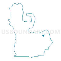
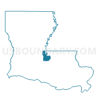
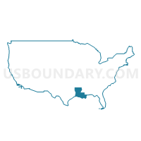
Precinct 13A, Pointe Coupee Parish, Louisiana
About
Outline

Summary
| Unique Area Identifier | 590232 |
| Name | Precinct 13A |
| County | Pointe Coupee Parish |
| State | Louisiana |
| Area (square miles) | 0.94 |
| Land Area (square miles) | 0.94 |
| Water Area (square miles) | 0.00 |
| % of Land Area | 100.00 |
| % of Water Area | 0.00 |
| Latitude of the Internal Point | 30.70421260 |
| Longtitude of the Internal Point | -91.42210950 |
Maps
Graphs
Select a template below for downloading or customizing gragh for Precinct 13A, Pointe Coupee Parish, Louisiana


Neighbors
Neighoring Voting District (by Name) Neighboring Voting District on the Map
- Precinct 12, Pointe Coupee Parish, LA
- Precinct 13B, Pointe Coupee Parish, LA
- Precinct 14, Pointe Coupee Parish, LA
- Precinct 15A, Pointe Coupee Parish, LA
- Precinct 15B, Pointe Coupee Parish, LA
- Precinct 8, Pointe Coupee Parish, LA
- Precinct 9, Pointe Coupee Parish, LA
Top 10 Neighboring County Subdivision (by Population) Neighboring County Subdivision on the Map
- District 12, Pointe Coupee Parish, LA (1,936)
- District 3, Pointe Coupee Parish, LA (1,898)
- District 7, Pointe Coupee Parish, LA (1,694)
- District 8, Pointe Coupee Parish, LA (1,546)